Auburn State Recreation Area - Mountain Bike Trail MapGuide to the best mountain
bike trails in the Auburn State Recreation Area |
|---|
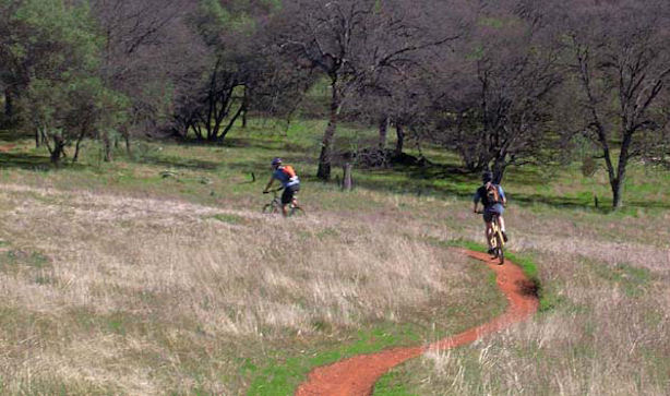
Auburn SRA Area Summary Description: While riding is possible year round, the Auburn State Recreation Area is particularly inviting in winter and spring, when the hillsides are green and snowpack covers many of the nearby higher-elevation trails. Summers are usually scorching. The river's many swimming holes, however, can help compensate for the heat. While the Auburn SRA has lots of multi-use single-track, not all trails are open to bikes. The trails are used heavily by hikers, equestrians and cyclists, so please be especially courteous to help maintain the peace. Enough trails are available to make riding here a great experience, particularly for intermediate and advanced riders. |
| The Auburn State Recreation Area is just one of the huge variety of mountain biking spots that the Northern Sierra has to offer. Discover more great rides. |
| The trail map tour below is a jpeg of the actual maps from our books and map-sets.
|
Auburn SRA Bike Trails Stagecoach Trail - Moderate fire road with great views. Culvert Trail - Steep single-track through open oak forest. Confluence Trail - Moderately technical single-track that hugs hillside along the American River. Lake Clementine Trail - Single-track and fire road that parallels the American River's North Fork. Foresthill Divide Trail - Fun, well maintained single-track through grasslands and forest. Foresthill Divide Connector Trail - Beautiful single-track connecting Lake Clementine and Foresthill Divide loops. Quarry Trail - Easy double-track trail skirts river's edge. Good family ride. |
| Directions to trailhead(s): The trailheads for the featured rides can be reached easily from the Foresthill Road exit in Auburn on I-80. Ride 1: From the Foresthill Road exit ramp, go to the east side of the overpass before turning right on Lincoln Ave. In 0.6 miles go left on Russell Road. You'll find parking for the Stagecoach Trail in 0.5 miles. Ride 2: From the exit ramp, follow Foresthill Road for 5 miles. Trailhead parking is on the right. Additional trailheads for Auburn SRA are off Hwy. 49 and Old Foresthill Road near the river confluence. |