Bay Area Mountain Biking
Download 16 PDF Maps for $10. Immediate Access
BONUS! - Get 12 Lake Tahoe PDFs with Your Purchase

 BONUS - Instant Access to PDFs of 12 great Tahoe rides at no extra charge
Benefits vs Similar Products:
* Includes immediate access to PDF versions of the set. No Waiting
* More portable than traditional books and more trail friendly than large fold-out maps.
* Combines text, photos and ride descriptions of a book with full-featured graphic quality of a map.
* Maps include trail descriptions, ski-style ratings and route markers.
* Includes suggested rides as well as the info to create your own great rides
About the Bay Area Mountain Biking Map Set:
Set of 16 two-sided maps include Mount Tamalpais and Marin Headlands near Mill Valley, Bolinas Ridge in Western Marin, Camp Tamaracho and Pine Mountain, China Camp State Park, and Annadel in the North Bay. East Bay maps include Briones, Tilden, Wildcat, Chabot and Redwood Open Space Parks, Mount DiabloState Park, and 2 maps covering Henry Coe State Park. Santa Cruz Mountains maps include El Corte de Madera (Skeggs) and other Mid-Peninsula Open Space areas such as Russian Ridge and Saratoga Gap. Close to Santa Cruz are Wilder Ranch State Park, and Soquel Demonstration Forest.
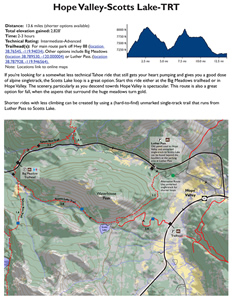
FREE Tahoe Maps include:
The Donner Summit region including the Hole in the Ground Trail and Grouse Ridge, North Lake Tahoe rides including Sawtooth Ridge near Truckee, the Western States and TRT Loop and great rides near Alpine Meadows. Tahoe/Nevada featuring the Flume Trail, and South Lake Tahoe including the Tahoe Rim Trail and Mr. Toads Wild Ride.
Read What Customers are Saying about BikeMapDude Maps.